...
- Course Descriptions:
- All GIS courses are described in further detail on the GIS Certificate program catalog page by clicking on the course prefix link. Descriptions speak to both online and Pensacola Campus course sections.
- We use industry-standard GIS software including ArcGIS Pro and ERDAS. We teach Python for GIS Programming.
- Courses include readings, lectures and lab assignments that teach students the theory, concepts, and software skills to conduct Geographic Information Science. Lab assignments are developed by program faculty and staff and are designed to teach students real-world applications.
- GIS courses are designed with the expectation that students are pursuing the GIS Certificate program and enrolling in all online GIS courses following a prescribed/ideal course sequence. GIS4043/L is a prerequisite course for all other GIS offerings and is the first class most students will begin with.
- All online GIS courses follow the Quality Matters instructional design rubric and several have met or exceeded standards in the peer-reviewed process. The Earth and Environmental Sciences department has been offering GIS courses online since 2006 and providing remote access to software through virtual machine technology for several years.
- Visit the GIS@UWF blog site student spotlight posts for an idea of what students are doing in our courses. See GIS Student Blog List link at the top right of the page for more.
- Course Duration: Online GIS courses are offered during the standard parts of terms 2 and 3. POT2 is the first half (8 weeks) and POT3 is the second half (last 8 weeks). We use the same parts of terms for Summer but the weeks are shorter (6.5 weeks). GIS Internship is the only course offered as a full part of term 1. See the UWF Academic Course Calendar for details.
- Cost: $330 for undergraduate course credits as seen on the 2nd page of the tuition rates document provided on the UWF Controller's office Tution and Fees page.
- Time Commitment: Expect to spend at least 10 hours per week in all GIS courses (maybe more). Learning GIS takes a lot of time and involves trial and error.
- Course Format: Asynchronous.
- Courses are taught completely online via Canvas including access to software via Argo Apps for GIS (links to info and required training). Students are never required to visit our Pensacola Campus or attend class virtually at a particular time.
- Lecture videos and assignments are available on the course site for students to review and complete independently within the provided timeframes and corresponding due dates. Most modules open early in the week where assignments are due within ~10 days of the module start date.
- Course content builds on previous lessons and assignments. It's important to complete all GIS course assignments in the order provided. The GIS lab is open to all GIS students during open lab hours. Some instructors allow students to work ahead but should not be expected for all courses.
- Classmates: Students in both undergraduate and graduate level sections access the same Canvas course site, and materials, and participate in class together. Graduate-level students will be expected to complete special assignments as clearly defined on the course site and syllabus. Students have the opportunity to communicate with one another (and with instructors) on the Canvas course open forum/help Discussion. A dedicated help form is provided with each module where students are encouraged to post questions about course content and assignments. GIS students in our online GIS programs come from different backgrounds and experience levels. We host a mix of students new to GIS and those who are already working in GIS positions. Most students work and are juggling work/life/school. Students can see what other students are creating in courses through their GIS Blog sites. UWF GIS will post current and alumni student spotlights as well as other relevant info to our UWF GIS Blog site, Instagram, Facebook, and Twitter pages.
- Instructors: Online GIS courses are taught by GIS faculty and adjuncts who teach primarily online and specifically for our programs. Adjuncts are working professionals in the field who bring real-world experience to our courses. Course topics and applications are varied to meet the needs of our students coming from and going into different industries. Expect to learn a lot from your instructors and classmates. Instructors and TA (if assigned) offer virtual office hours for students to optionally attend and ask questions. These are typically held in the evenings as most of our students work during the day. Students to attend the virtual office hours regularly tend to know what is going on in class and do well. Outside of the course site and virtual office hours, instructors are available by email and appointment when needed.
- Prerequisites - Special Technology/Hardware/Skills Requirements:
- In order to participate in our online courses, students MUST have access to their own laptop or personal computer and consistent broadband internet access (high-speed). Access to software, required to participate in GIS courses, is provided to students through Argo Apps for GIS (virtual machine) and assessed with course tuition. A good high-speed internet connection is required for an optimal experience while using Argo Apps.
- We offer students access to the software for local installation but your computer should meet the minimal hardware requirements for Esri ArcGIS Pro 2.8 software.
- We don't require previous knowledge or experience in GIS but it's important to possess basic computer skills for GIS. This This is a very technical program and we will not have time to teach basic skills. ADA Statement here
- Certain aspects of GIS software require students to have sight and hand-eye coordination (certain abilities) to practice GIS and use the software (any GIS software). Students with colorblindness have done well in our program and should not be too concerned. If you have a disability that impacts your full participation in a course you've enrolled in, please contact the Student Accessibility Resources at 850-474-2387 or by email, sar@uwf.edu for additional support.
- Reading and writing are the main ways you'll communicate in our online courses. All materials and communication will be conducted in the English language. Adhering to basic computer ethics and professionalism will be expected by all.
...
- Before You Enroll - Book an Advising Appointment in Navigate (must be an accepted UWF student to access). New students should meet with their advisors to develop a course plan. Non-degree-seeking students do not require an Advising Pin to enroll but are strongly encouraged to meet or communicate with the program advisor regarding plans once a semester.
- Holds can prevent registration. To view and resolve holds, follow the instructions provided for Viewing Holds. Complete the end-of-course survey (SAI) to avoid a hold in between semesters.
- Registering for Courses for step-by-step instructions on how to register for courses. Notice several other useful topics/pages listed on the left-hand navigation you may want to refer to.
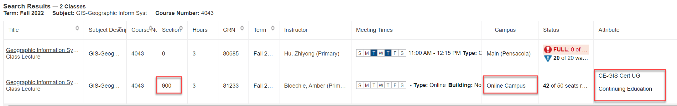
- Online GIS Course sections have unique attributes to help ensure students are enrolling in the proper section. Sometimes we offer the same GIS course (prefix and title) both online and at Pensacola Campus so it's important to recognize the differences in course search results. In the screenshot below, the course search result for "GIS4043" returned two course sections. The online GIS Certificate course section has 3 distinct differences highlighted in the red box. When in doubt, your advisor can provide the Course Reference Number (CRN) you should enroll in.
Required Textbooks
Visit the UWF bookstore to view your required textbooks. https://www.bkstr.com/westfloridastore/shop/textbooks-and-course-materials
Please note the course reference numbers are important - CRNs should be confirmed to ensure you're accessing the materials required for our fully online GIS course sections.